Suffolk County Office of Emergency Management wants you to know what Storm Surge Zone you live in. Use the County’s “Know Your Zone” tool so you may plan and prepare in the event you need to evacuate when storm surge affects Long Island.
Residents and visitors can identify the Storm Surge Zone they are in by using this tool. Please note this important point: Storm Surge Zones are not only for ocean facing properties but are located all around the island, both north and south shores as well as between the eastern forks and inland bays.
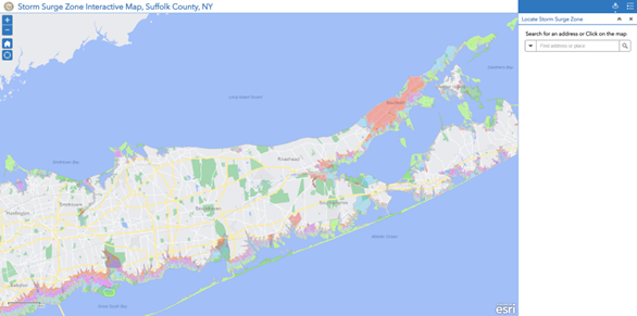
The tool is very simple to use. Simply begin to enter the first line of the address of your desired location. The address from the pulldown list should populate rapidly. Alternatively, you can also hold down the left button to drag the map to the scroll down to desired location and left click to display the location zone information.
If you determine that your home lies within a storm surge zone that has the potential to flood, you may want to make arrangements to stay with relatives or friends who live in an area that is less likely to flood, such as along the spine of Long Island near the Long Island Expressway. You should plan on going to a shelter only as a last resort.
We recommend that all Suffolk County residents purchase flood insurance. For those residents that live in a storm surge zone, it is particularly important to purchase flood insurance. Click here to learn more about flood insurance.
If you believe that you may need assistance during an evacuation please register with our Emergency Preparedness Registry.Click here to learn more about the Suffolk County Emergency Preparedness Registry.
More Ways To Be Informed:
The Shelter and Storm Surge Zone Mapping Tool was developed by Suffolk County through the combined efforts of the Departments of Information Technology and Fire, Rescue and Emergency Services.
Click here to downloading a PDF Map of the Storm Surge Zones in Suffolk County.